
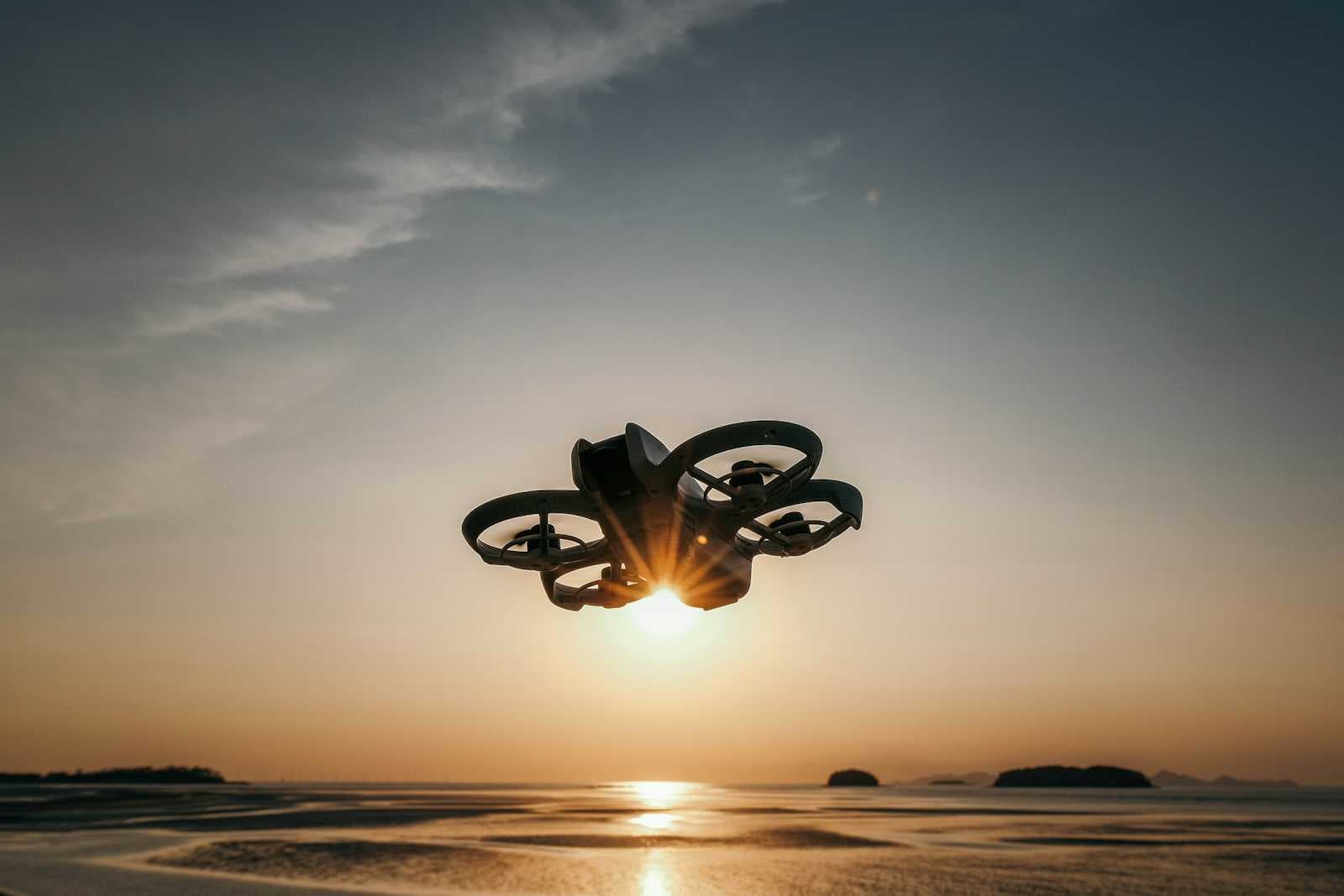
Computer Vision for Drone-Based Surveillance
Head (AI Cloud Infrastructure), Presear Softwares PVT LTD
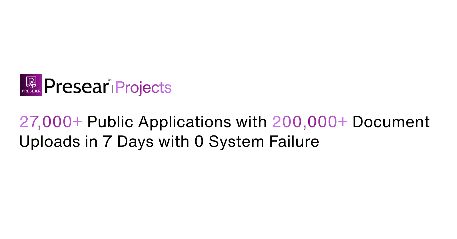
Executive summary
Monitoring large terrains — borders, coastlines, critical infrastructure, and remote assets — is a major operational challenge for defence intelligence units, border security forces, and aerospace agencies. Manual monitoring is slow, expensive, and error-prone. Presear Softwares PVT LTD offers an integrated computer-vision (CV) solution for drone-based surveillance that automates detection, tracking, classification and actionable alert generation. This use case explains the problem, the Presear solution, technical architecture, deployment scenarios, privacy and compliance considerations, and expected operational and financial benefits.
The core pain point
Large-area surveillance requires continuous attention across vast spaces. Human operators monitoring video feeds can miss subtle signals, suffer fatigue, and are hard to scale. Specific pain points include:
Scale: Hundreds of square kilometers cannot be reliably monitored by human teams.
Latency: Time between an event (intrusion, vehicle movement, anomalous thermal signature) and human detection can be minutes to hours.
False alarms: Rule-based or manual observation produces too many false positives, wasting resources.
Environmental complexity: Lighting changes, weather, foliage, and terrain make consistent detection difficult.
Cost & logistics: Fuel, manpower, and infrastructure cost for continuous manned surveillance are prohibitive.
These pain points reduce situational awareness, slow response times, and increase operational risk.
Presear’s computer-vision drone surveillance solution (overview)
Presear Softwares proposes a modular CV platform optimized for integration with fixed-wing and rotary drones, tethered UAVs, and ground stations. Key capabilities:
Real-time object detection & classification: Vehicles, humans, boats, UAVs, animals, and infrastructure elements using optimized deep-learning models.
Multi-sensor fusion: Combine RGB, thermal (IR), LiDAR, and radar-derived telemetry for robust detection under all-weather and day/night conditions.
Automated persistent tracking: Maintain identity across frames and sensor handovers (e.g., when a target moves between drones or to ground cameras).
Anomaly detection and behavior analytics: Detect loitering, route deviations, unexpected gatherings, or unauthorized access using time-series and graph-based models.
Edge-first inference: Model optimization and hardware-aware deployment for running on drone edge devices (NVIDIA Jetson, Intel Movidius, Qualcomm) to minimize bandwidth and latency.
Cloud-assisted analytics & archival: Elastic cloud services for model updates, long-term video storage, forensic search, and fleet-wide behavioral analytics.
Explainable alerts & visualization: Alerts accompanied by keyframes, confidence scores, tracked paths and short video clips for faster human verification.
Technical architecture
Perception layer (Onboard): Lightweight neural networks (e.g., pruned YOLO/SSD variants, quantized transformers where appropriate) run on flight hardware to provide immediate detections and metadata. Thermal and multispectral inputs are pre-processed with sensor-specific calibration.
Edge aggregator (Ground/tethered station or onboard co-processor): Aggregates detections from multiple drones, fuses sensor data, performs higher-order analytics (e.g., multi-object tracking, re-identification), and applies rule engines to reduce false positives.
Network & secure telemetry: Encrypted low-latency links (mesh, LTE/5G, SATCOM fallback) transmit compact metadata and prioritized clips to command centers. Raw high-resolution video is uploaded on-demand or on return-to-base to minimize bandwidth costs.
Cloud & analytics: Central cloud services receive curated data for model retraining, long-term storage, geospatial visualization (GIS overlay), and cross-mission correlation.
User interface & integrations: Dashboard with map-based live view, timeline, alert inbox, and API connectors to C2 systems, SOS dispatch, and local law enforcement databases.
Core features and capabilities (detailed)
Detection & classification
Specialized models trained on domain-specific datasets (vehicles on desert terrain, small boats in coastal clutter, camouflaged humans) to reach high precision and recall. Transfer learning plus targeted data augmentation (fog, rain, motion blur) reduces domain gap.
Tracking & re-identification
Combines motion models, appearance embeddings, and spatio-temporal association for robust re-ID even after occlusion or sensor handover.
Multi-sensor fusion
Thermal images combined with RGB greatly improve detection in low light; LiDAR adds depth cues for accurate size estimation and occlusion reasoning.
Anomaly detection
Unsupervised and semi-supervised systems learn normal patterns for a region and flag deviations—useful for detecting unauthorized encampments, dead vehicles, or suspicious rendezvous.
Bandwidth management & edge-first design
Intelligent compression and event-driven upload ensures command centers receive only high-value video — conserving bandwidth without compromising situational awareness.
Explainability & audit trail
Every alert includes provenance metadata: which drone, sensor, model version, confidence, and keyframes to assist human decision-making and for legal/operational audits.
Deployment scenarios
Border surveillance
Continuous or scheduled drone patrols along border strips with CV-enabled detection of crossings, vehicle movements, and unusual gatherings. Alerts routed to border units with suggested interception vectors and historical movement context.
Coastal & maritime monitoring
Detect small craft, suspicious boarding activity, and track vessel movements across night/day cycles using thermal + RGB fusion. Integration with AIS and coastal radar provides corroboration.
Critical infrastructure protection
Perimeter monitoring for power plants, pipelines, and airports — detecting intrusions, unusual equipment movement, or wildlife hazards that could cause outages.
Disaster response & search-and-rescue
Post-disaster drone sweeps to find survivors, map damage, detect heat signatures, and prioritize rescue operations with geo-tagged, time-stamped evidence.
Data, privacy, and compliance
Presear’s platform is built with privacy-by-design and compliance-first principles suitable for defence and civilian deployments:
Data minimization: Edge-first inference and selective upload reduce personal data transmission.
Access control & logging: Role-based access, end-to-end encryption, and immutable audit logs for chain-of-custody.
Redaction & retention policies: Automated face-blurring or pixelation for civilian regions, configurable retention periods for video and metadata per regulatory needs.
Compliance: Support for national defence guidelines, telecom regulations, and export-controlled cryptography where applicable.
Integration & interoperability
Presear ensures the solution plugs into existing ecosystems:
Standard APIs (REST/gRPC) and message buses for C2 integration.
Open standards for geospatial data (GeoJSON, WMS) for GIS tools.
Interfacing with legacy video management systems (RTSP, ONVIF) and intelligence databases.
Operational benefits & ROI
Improved detection and response times
Real-time detection and prioritized alerts reduce time-to-action from minutes/hours to seconds.
Reduced manpower costs
Automating routine monitoring reduces operator headcount needed for continuous surveillance, freeing human analysts for verification and higher-value tasks.
Higher mission success & lower false positives
Domain-trained models and multi-sensor fusion slash false alarms, improving trust and operational tempo.
Scalable & modular
A fleet of heterogeneous drones integrated into Presear’s platform scales surveillance capacity without linear increases in command staff.
Measurable KPIs
Key metrics: events detected per km/day, false positive rate, average time-to-verify, bandwidth cost per mission, and percent uptime. Presear provides dashboards and monthly reports to quantify gains.
Case example (hypothetical but realistic)
Scenario: A 120 km border sector with mixed terrain (riverine, forest patches, and open plains). The client operates a mixed fleet of rotary and fixed-wing UAVs with tethered observation masts at key chokepoints.
Before Presear: Human operators monitored 24/7 + fixed towers. Average time-to-detect incurs 18–45 minutes with many false alarms from wildlife and weather. High manpower costs and slow response.
After Presear deployment: Edge models detect and classify human movement and vehicles with a 92% precision and 88% recall in field trials. Anomaly detection flags unusual night-time gatherings. Average time-to-detect drops to under 90 seconds for high-priority events; verified alerts reduced false positives by 70%. Operational cost reduction of 35% driven by lower repeat patrols and reallocated manpower. The client also uses the forensic archive to prosecute repeated cross-border smuggling.
Implementation roadmap & support
Presear follows an iterative, low-risk rollout:
Pilot (1–3 months): Small-area deployment with 2–4 drones, establish data pipelines, evaluate base model performance, and produce success metrics.
Optimize (3–6 months): Domain adaptation with collected mission data, sensor calibrations, and integration with local command systems.
Scale (6–12 months): Fleet-wide rollout, model governance, scheduled retraining cycles, and operator training.
Presear provides field support, training, and periodic model refreshes. Optional managed services include 24/7 monitoring, model ops, and SOC-style alert triage.
Risks and mitigations
Adverse weather & sensor failure: Use multi-sensor redundancy and graceful degradation to maintain core detection capabilities.
Adversarial tactics (camouflage, jamming): Continuous model updates, spectral analysis, and independent sensor modalities (radar/LiDAR) to counter simple evasion techniques.
Legal & privacy concerns: Pre-deployment legal review, configurable data policies, and strict audit trails.
Conclusion
Presear Softwares PVT LTD’s computer vision platform for drone-based surveillance transforms large-area monitoring from a manpower-intensive, error-prone task into a responsive, automated capability. By combining edge-first CV models, multi-sensor fusion, robust tracking, and explainable alerts, Presear reduces detection time, cuts false positives, and delivers measurable operational savings for defence intelligence units, border security forces, and aerospace agencies. The modular design, compliance-first approach, and clear implementation roadmap make this solution practical for pilot-to-scale adoption.
If you'd like, Presear can provide a tailored proposal including a pilot plan, cost estimate, and a demo of the CV dashboard using sample data from your region.